Sunday, 24 April 2016

Whitwell and Stenbury

Another Sunday afternoon stroll on our beautiful Island. This time we headed south to Whitwell and parked near the church, and followed the route suggested by Isle of Wight Ramblers route 'Whitwell, Stenbury' in their 'Twelve more favourite walks' booklet.

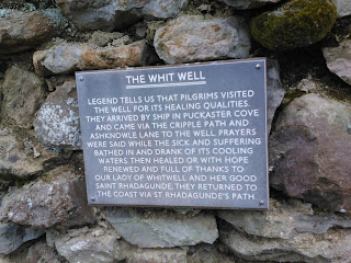
The route led us up the main road past the church and rectory, then turned left down a broad footpath between houses. On the side of the footpath was an old water hydrant, installed in the village in the 1800s, and the 'White Well' which the village is apparently named after. This used to be a place of pilgrimage for the healing water's of the well, dedicated to 'Our Lady of Whitwell and St Rhadegund'.


The path led on down to a stream and then across a field to a metal gate. Apparently the old railway line led through here, but there was nothing obvious to suggest this (we looked hard!). The path continued upwards towards Nettlecombe, a hamlet that is all that remains of a medieval village, and past three large ponds on the way. Nettlecombe looked lovely - a small community nestled in a valley with countryside to die for. It was the best venue for sledging that I have ever seen! The pathway continued uphill, via NT3 and NT119, onto Stenbury Down. The views across the Island were magnificent; we could see all the way up to Tennyson Down and down the coast to Blackgang then round the southern end of the Island. Turning the other way we could see the Solent. In between all of this was beautiful, rolling countryside with fields as far as the eye could see, and spring flowers in every verge and hedgerow.  Glorious.

We followed the path to Week Farm, crossed the farmyard and continued on up the hill towards metal towers that overlooked Wroxall, and where the path joined with the route to Gat Cliff and Appuldurcombe.  At this point we turned left and plunged steeply downhill towards Newbarn Farm, said hello to the farmer as we crossed the farmyard, and followed a path past sheep paddocks. Here we saw a newly born lamb, still wet and bloody, lying near its mother and the placenta. Strangely cute! There were lots of lambs here, of varying ages, gambolling happily around the fields. We saw a couple feeding and their little tails were waggling with joy! The country here seemed ageless, and we could well imagine that not much had changed for several centuries and almost expected Mr Darcy to come galloping over the hill. He didn't, sadly. We passed moss-covered, crumbling, dry stone walls, and tripped along an uneven pathway towards Stenbury Manor and passed between this building and the farm outbuildings. The manor appeared shut up, with shutters at every window, but that could just have been to keep out the prying eyes of passing walkers.

After the manor the path returned to Nettlecombe, over a series of stiles and past more happy lambs, and eventually rejoined the well path and back to Whitwell. We decided we needed a cup of tea so drove to The Buddle Inn in nearby Niton to get one. We also ordered cheesecake which turned out to be rather more expensive than we anticipated, but was suitably yummy.

This was a delightful walk, not too muddy, and steep in places, with lovely wildlife. We saw flowering gorse, blackthorn blossom, cowslips, primroses, stitchwort, bugle, bluebells, rabbits, horses, cock pheasants in full spring glory, hen pheasants, alpacas, cattle, sheep and lambs.

Distance: 4.5miles
Pathways: NT3, NT119, NT9, V62

Bluebells

Rolling countryside

Wind-blasted trees

Stenbury Manor


Saturday, 9 April 2016

Medina Estuary

Today was the annual sponsored walk for St. Mary's Church, so I thought I'd join in. Some parishioners met up at the Church, and the rest of us met at the start of the Cowes-Newport cycle track on Arctic Road. Once we had all gathered here, (there were 14 of us), we set off for Newport. The weather was pleasant and warm, and we got going at a good pace chattering away and admiring the views of the River Medina, as well as dodging cyclists and runners. A popular path! After about an hour we reached Dodnor picnic area and were met by two chaps who had laid a tablecloth over a picnic table and provided tea, coffee and biscuits for us. Very nice! Once refreshed we headed on to Newport, popped into the Quay Arts Centre to use the facilities and said goodbye to four of the walkers who were now going home.

The rest of us picked up the path on the opposite side of the river and strolled on past the site of the Isle of Wight Festival, and onto a newly refurbished path along the river to Island Harbour. At Island Harbour we used a lock gate to cross over the harbour entrance and onto the next part of the path. Shortly afterwards we saw that the pathway was closed, but thought we'd chance it and carried on anyway, especially after walkers coming in the opposite direction said they had got through. However, we soon discovered that the main route was underwater and wandered up the field edge looking for an alternative. Unfortunately, one of our party slipped over in the mud and hurt his ankle, and the weather turned cold, wet and squally, so we decided to head back to the harbour before there were any more accidents. Luckily there was a café there, The Breeze, so we stopped for a coffee, called the injured chap's wife to collect him and decided what to do next. Half the party decided to head back to town and catch the bus home, and the remaining five of us decided to continue on a slightly alternative route.

We headed up the lane to the main Newport to Ryde road, turned left and picked up the old East Cowes Road, then walked along until we got to Beatrice Avenue. We headed down here towards St Mildred's Church, designed by Prince Albert, and then down through a housing estate and into East Cowes and thence to the chain ferry and home. We managed to run for the chain ferry as we could see it was about to leave and really didn't want to sit around and wait for the next one, and the lovely operators waited for us.

This was a lovely walk with lovely people and I shall try and tag along again next year!

Distance: 11.7 miles
Sculptures at Seaclose park

PS Ryde Queen at Island Harbour

Bench at Whippingham

St Mildred's Church, Whippingham

Friday, 8 April 2016

Mottistone to the Sea

I dragged the teenager into daylight and headed for the West Wight today. We parked at the National Trust car park at Mottistone Manor, then followed their suggested route towards the coast. This led through the churchyard down a short lane, over a stile and onto a footpath. This was slightly squishy in places, but had a stream to the right, and plenty of herbage; the nettles were growing, and cow parsley was coming into bud, and all the hedgerow plants were greening up. We followed a pair of mallards to a wild meadow, where they took to a small pond, and we continued onwards.

The path turned right at a junction, bordered by a laid hedge to the left, and we headed onwards to walk along the edge of another stream and a small woodland. This latter was very pretty in the dappled sunlight, with the deciduous trees putting out leaves, and masses of cow parsley on the path. We could hear the songbirds warbling in the trees and hedgerows and noticed a few bees and bumblebees buzzing among the early wildflowers. The path crossed a small bridge and another stile into a rather soggy meadow, coming out after a little while onto the military road.

We turned right, passed two cottages, then crossed over the road to follow a permissive path through fields to the cliff edge at Sudmoor Point, and picking up the coastal path. There was a glorious view here all along the coast from Blackgang to Tennyson Down, and looking down over the landslip we could see that the tide was far out and that the rocky reef was exposed. Unfortunately there was no access to the beach as far as I could see, so we didn't get closer. The teenager was tired so that was probably a good thing! We followed the coastal path for a while until we met a footpath going inland, and followed this back to the military road, and then crossed over and picked up the final path back to Mottistone. This was a lovely farm track between high hedges, secluded from the breeze and warm in the spring sunshine, and led us back to the church and then the car park.

As the teenager had made it all the way round, I rewarded her (and me, obviously) with an ice cream from the van at Compton Bay before driving home along lots of country lanes, avoiding many suicidal pigeons and a pheasant.

Distance: 2.8 miles
Footpaths: BS74, Coastal Path, BS75, BS100

Mottistone Church

Woodland Stream


View from the coastal path towards Freshwater

Sunday, 3 April 2016

Chale Green and the Hoy Monument

Proper walking today, on an overcast afternoon. I joined my friend and her two sons for a circular walk from Chale Green, following a route in one of Isle of Wight Rambler's Association's books. We parked in a layby on the main road, crossed over the road onto a patch of grass then over a footbridge and up a muddy track. The mud came and went, but the hill continued, rising almost 400ft in the first mile. We passed through a lovely little wood full of hazel bushes and carpeted with bluebell foliage where the boys had fun looking for sticks. We found a couple of concrete seats modelled on ripe fungus which we all tried out, and found to be surprisingly comfortable!

The track continued steeply up, coming out into fields before plunging back into woodland again. We came to a junction and followed the left hand path up an extremely muddy path which led to the crest of St Catherine's Down and the Hoy Monument. The monument was huge, which was to be expected as it could be seen for miles around. It was erected by a merchant to commemorate a visit to the UK by Tsar Alexander, and later had a tablet added commemorating soldiers who died at the Battle of Sevastapol. More information can be found on the National Trust page.

After we had had a brief rest and refreshments we continued, heading back to the main path and taking the other fork. This was also muddy, and led through fields and woodland bordering the down, bringing us eventually to the road. We crossed over and followed a footpath through a field, along a ditch boundary with a stream, before coming to a small sheep farm. As we approached, the farmer came out with a big smile, and asked the children if they would like to see some new born lambs. They did, as did both adults, so we followed her to the barn and were introduced to a ewe and two 12-hour old lambs. We then got to cuddle a baby baa lamb! Eldest boy declined, and youngest boy was a bit small, but both adults were straight in there after assuring the farmer that neither of us were pregnant! What fun!

The walk continued; after we left the farm driveway, the path turned steeply right and then even more steeply uphill, coming out on a broad green pathway high above the surrounding farmland. We found an unusual memorial that looked rather like a prone barrel, and which was covered in inscriptions of dates and names. Curious. Once home I did a little searching and am reasonably sure it was a commemoration of shipwrecks off the west coast of the Island. The path soon descended again, and led across the lawn of Pyle Manor then into Windmill Copse, another pleasant patch of woodland. This led past a deer park, where we watched a herd of deer watching us. They were well camouflaged against the hill.

Further on, the path led through a swampy section of woodland, with a rickety boardwalk to walk on. This was fine until the very end where the boardwalk suddenly ran out, so we hopped across the last few feet on semi-sunken branches and logs.  The path led back uphill (not steep) and across a few fields until we returned to Chale Green, muddy, tired and happy.

Route: http://gb.mapometer.com/walking/route_4284746.html
Distance: 4.5 miles
Footpaths: C1, C37, GL60, C3, C5, C4, C21, C22, C23, C33

Mushroom Chairs

Hoy Monument

View to the West Coast

Baa Lamb

Shipwreck Memorial

Primroses

Swamp path


Saturday, 2 April 2016

West Wight Alpacas

As the sun was still out we had a family outing (three generations) to West Wight Alpacas in Wellow. I had heard lots of good things about this place from a variety of people, so when Mum suggested we went I leapt at the idea.

We drove through the back lanes of the Island to get there (not necessary really, but a pleasant drive), and arrived at the site on the main Wellow road. We paid our small entrance fee in the café and headed off to admire the chickens, ducks and guinea fowl in the nearby paddock. The chickens were plentiful and came in a huge range of colourings, and were accompanied by the most splendiferous cockerel I have ever had the pleasure to lay eyes on. He had magnificent green, red and bronze colouring and strutted his stuff amongst his harem. We purchased a pot of bird food and all had fun throwing it for the birds to eat, with the teenager piling some on her shoe and allowing chickens to peck the seed off, much to all our amusement.

After this we wandered around the outside of the paddocks admiring the alpacas, donkeys, rheas and llamas. The alpacas and llamas were unshorn and very fleecy, and came in a variety of shades of cream and brown. There was a choice of a short walk and a long walk around the paddocks, and we chose the short walk as there was a chilly breeze today.

Once we had seen all the animals we stopped in the cafĂ©  for refreshments. I had a very generous pot of tea and shared a tasty rock cake with my Mum, while the teenager scoffed a bowl of freshly made chunky chips. There was also a shop selling alpaca and llama wool, and a range of handmade knitwear. We admired all and I wished I was a better knitter! To finish off I bought some fresh eggs, blue in colour. Beautiful! This was a lovely afternoon out, and I shall definitely visit again.


Friday, 1 April 2016

Bembridge Down

We tried a new route today, much to the teenager's disgruntlement. I realised that I had never walked up Bembridge Down to Culver Cliff so as today was sunny and reasonably warm we gave it a go. I parked at Yaverland, then we crossed the road and joined the coastal path behind the sailing club climbing uphill over turf towards a shrubby area. Here the path became more formal and led through flowering hawthorn and gorse, past a derelict gun battery and then up and past a holiday village. beyond the chalets the path opened out onto Bembridge Down proper, denoted by a National Trust sign and information board. We detoured around a muddy patch then began our ascent.

The down spread out around and above us, with the beacon of the Culver Cliff monument beckoning us from the hill top. To our right was the cliff edge, and as we ascended, the extent of Sandown Bay became apparent. I knew it was a large bay but had not seen it from this impressive perspective before. We stopped for a picnic lunch on a patch of springy turf overlooking the bay, and watched the sun glinting on the sea, and container ships lining up in the channel; these appeared empty so we assumed they were waiting to be called into port in Southampton. We also watched a hawk, possibly a kestrel, glide overhead on the breeze then turn and hover effortlessly above the cliff looking for prey. Glorious.

We continued upwards and made it to the top fairly quickly. To the teenager's delight there was a café serving ice cream and fizzy drinks so we paused here for refreshment. I went and explored to the end of the promontory and discovered Culver Battery, with the remains of two large gun emplacements. There was also the site of Culver Signal Station as well as a Beacon Basket. I had had no idea any of that was there. Apparently it was used by the military until the 1960s, and not much is known about what went on there. It is now managed by the National Trust. The views across the east end of the Island from here were fantastic; I could see Brading Haven, Bembridge and St Helen's, and across to Ryde and Portsmouth.

Once I had rejoined the teenager we inspected the monument which was dedicated to the Earl of Yarborough and was quite an impressive piece of masonry. We then walked down the lane towards Bembridge Fort, which is also managed by, and being restored by, the NT, but is only open occasionally. Bembridge Fort is another Palmerstone defence against possible invasion by the French in the 1800s. After this we returned to the downland and stomped down the hill to the coastal path, retracing our steps to the car. An invigorating walk, and one that could be taken considerably further.

Distance: 3.8 miles

View across Sandown Bay

Landslip


Yarborough Memorial

Gun Emplacement

Bembridge Fort

Gorse