Showing posts with label monument. Show all posts

Monday, 19 August 2019

Niton and Chale

Gorgeous walk with friends today after a week of miserable weather. We started in Niton and headed up Pan Lane to the downs, then followed the path to the Hoy Monument. Along the way we were picking and eating plump blackberries and admiring the many wildflowers in the hedgerows and in the fields.  We turned left near the monument, walked down the path to a junction and turned left again heading eventually over fields, past a dairy farm, and down to the road. We turned left again and before very long were at the Wight Mouse Inn at Chale. We stopped for lunch, obviously! This was scrumptious, and I recommend the stilton burger.

After lunch we carried on along the road to the junction with the military road, turned left and picked up the coastal path and headed uphill towards Blackgang Chine. The next path went over a field, the oversold car park, and headed upwards to Blackgang View Point car park. Fantastic views up the west coast from here. At the far end of the car park we picked up the next path and headed for a time along the cliff top in a stiff breeze before turning left after a stone wall and picking up a path back to Niton. This led past a wheat field and eventually back to the village. There were more glorious views here, across to the downs in the late afternoon sunshine. We live on a beautiful Island.

Route: www.plotaroute.com/route/907930
Distance: c. 5.5miles


Tuesday, 16 April 2019

Monk and Merchant walk

It's April for heaven's sake, and this is the first proper stomp I have had. I have been a bit busy...  I met up with a friend and we headed to the White Mouse Inn at Chale for a sandwich and a cuppa, then drove up the hill to the Blackgang Viewpoint car park. From there, we crossed the road and headed up hill towards St Catherine's Oratory (Pepperpot), and paused  for a while to take photographs, before heading along the crest of the down to the Hoy Monument. This is a huge stone column erected by a local merchant with Russian connections, to celebrate the visit of Tsar Alexander I to Britain. As you do. 

From there we turned left onto a footpath heading down the hill, going through several gates and passing to the side of a property called the Hermitage. The path led through a field to a quiet lane, rejoined a footpath and led towards Moorhills Farm, which housed a timber merchant and sawmill. Now, we were busy chatting and missed our turning and continued down the lane past ponds and streams until we arrived at the main road through the village of Bierley. Once we had realised our error we doubled back, found the footpath, waved at the chaps in the sawmill, and carried on across fields heading towards the oratory which we could see on a distant hill.

We passed Downcourt Manor Farm and turned uphill, having rather lost the path, and clambered onwards coming to a barbed wire fence with no obvious route through. We managed to climb through and headed upwards, spotting what we thought was our route. We also stopped to admire a hare bounding along the hill in front of us. We were again thwarted by a barbed wire fence, more robust this time, which stood between us and  a herd of cows. We turned right and followed the fence along until we saw the footpath and were able to get to it. From here we headed back towards the oratory hill, skirting along the base of it and then back down the hill to the car. This was a lovely walk, which would have lovely views on a clearer day!

Intended route: https://www.nationaltrust.org.uk/st-catherines-down-and-knowles-farm/trails/the-monk-and-the-merchant-walk

Approximate Route: https://www.plotaroute.com/route/809584

Distance: c. 5.5. miles

St Catherine's Oratory
Benches at Moorhills Farm


Wednesday, 11 April 2018

West Wight

The sun came out today for the first time in ages so a friend and I headed to Freshwater Bay and sauntered up Tennyson Down. I had forgotten that the Down goes up and up and up, but luckily the views were worth it every time I had to stop to catch my breath (quite often!). We could see a long way down the west coast of the Island, as well as along the north coast with glorious views of the River Yar sparkling in the sun, Hurst Castle and Fort Albert. The Solent was flat as a pancake and very blue.

We continued to the Tennyson Monument and then down to the replica of Nodes Beacon and carried on for a while until the Old battery was in sight. We decided to head back then as we weren't sure there was still a cafe there and were getting peckish. We went back the way we came, admiring wildlife on the way; we saw a very tame robin, a kestrel, lots of small brown birds, gulls, and a very hairy brown caterpillar. There were also lots of solitary bees around, the occasional red-bottomed bumblebee and a few flies.

Back in Freshwater we had a cup of tea at a cafe but didn't fancy their sandwiches so headed down the coast to Isle of Wight Pearl, and were extremely satisfied by the food, and sorely tempted to try their cakes. We resisted, and instead strolled round the corner and walked down to Chilton Beach and along to Brook where we picked up the coastal trail and walked along the cliffs to the car park. On a couple of occasions as we walked along the beach parts of the cliff started crumbling; these were only mini falls of pebbles and soil, and we were glad nothing worse happened! The beach was, as ever, lovely and mostly deserted apart from the occasional dog walker. We didn't get back in time for cake unfortunately, but will definitely try again in the future!

View across Tennyson Down towards the Needles

Distance: approx 9.5 miles in total

Tuesday, 18 July 2017

Nettlestone to Yaverland

Today I helped take twelve teenagers on a stroll across the east of the Island. We got a coach to Nettlestone and walked towards the Priory Hotel, then followed the footpath round and ended up at The Duver, St Helen's. This is a lovely patch of National Trust land, sprinkled with wildflowers among the short turf. After a quick rest break we headed across the causeway and into the outskirts of Bembridge. The road led along another causeway, past the yacht club and numerous houseboats, and to the Tollgate café opposite the Pilot Boat Inn. We stopped at the café for lunch (some picnicked, and some bought food), then carried on.

This was the point where my dodgy map reading skills came into play, and we pootled up a lane going in the wrong direction. Oops. I soon realised my mistake however, and we turned round and joined up with the path we were meant to be on. We followed the High Street  to Bembridge Windmill and then followed the lane into the woods, across a road, past a holiday camp and onto the cliff path to Culver Down. Some of the kids groaned when they realised we had to climb the down, but they all managed it faster than I did! We stopped at the Yarborough Monument at the top and admired the view, and I admired the wild flowers, had a drink and a snack (I got an ice cream) before walking down the other side of Culver Down to Dinosaur Isle where we met the coach again.

This was a boiling hot day, with teenagers who were generally not used to walking so far, and it went really well. Another route tomorrow.

Distance: 7.3 miles

View from Yarborough Monument


Sunday, 25 September 2016

Blackgang to Hoy Monument

First walk of the autumn today, in glorious sunshine and a stiff breeze. We parked at the Blackgang Viewpoint carpark, above Blackgang Chine theme park, and crossed over the road to steps leading to a field. The path led through a herd of cows, pastel coloured and seemingly kindly, and then upwards towards St Catherine's Oratory, or The Pepperpot as it is known locally. This stone tower was built in the early 1300s, apparently as a penance by a local landowner who stole wine from a shipwreck. It was originally a chapel with a beacon for shipping, but all that remains is the tower. Next to the oratory is a bronze age barrow, excavated, and further along is the 'Salt Pot', which is the stone circular base of an eighteenth century lighthouse that was never completed. We paused on the way up to watch what we thought was a kestrel, hovering above its prey, swooping to catch it, then sailing back up into the sky and swooping effortlessly along the ridge in the breeze. Beautiful.

We continued, through a field of skittish and distinctly less friendly cattle, down a steep slope past what may have been ancient agriculture (hill with lots of mini terraces), then through a gate into National Trust land and a well maintained path that led along the ridge of St Catherine's Down to the Hoy Monument. This was a very pleasant stroll, with glorious views across the Island to either side in the golden autumnal sunshine. The Hoy Monument is huge, and was erected to commemorate a visit to Great Britain by the Tsar of Russia. I don't think he made it to the Island! There is also a commemorative plaque for the troops that died at Sevastopol. Strange place to put it. We continued past the monument to a dead end, then retraced our steps to a side path and descended through woodland to pick up a path at the base of the ridge.

This path led along the edge of the wood and gradually took us back up the hill to the edge of the National Trust land. Wanting to avoid the cattle, we took a path that skirted the base of the ridged hill, only to find the cattle had moved and were ahead of us, so, wimps that we were, we retraced our steps and climbed back up the hill (on the other side of the fence!) to the trig point and the pepperpot. It was extremely windy at this point and we were glad not to have small children with us. We paused inside the pepperpot (no wind here) then plunged back down the hill towards the car park. We felt we had earned refreshment so we each bought an ice-cream from the van in the car park, and wandered along the cliff path to look down on Blackgang Chine. To finish the trip, we blasted up the Military Road to Freshwater Bay before returning home. Gorgeous afternoon!

Distance: 3.6 miles


View along the West coast from the Pepperpot.

Chale mackerel

Ridged hill

Hoy Monument

Maple tree

Wight landscape

St Catherine's Oratory

Sunday, 3 April 2016

Chale Green and the Hoy Monument

Proper walking today, on an overcast afternoon. I joined my friend and her two sons for a circular walk from Chale Green, following a route in one of Isle of Wight Rambler's Association's books. We parked in a layby on the main road, crossed over the road onto a patch of grass then over a footbridge and up a muddy track. The mud came and went, but the hill continued, rising almost 400ft in the first mile. We passed through a lovely little wood full of hazel bushes and carpeted with bluebell foliage where the boys had fun looking for sticks. We found a couple of concrete seats modelled on ripe fungus which we all tried out, and found to be surprisingly comfortable!

The track continued steeply up, coming out into fields before plunging back into woodland again. We came to a junction and followed the left hand path up an extremely muddy path which led to the crest of St Catherine's Down and the Hoy Monument. The monument was huge, which was to be expected as it could be seen for miles around. It was erected by a merchant to commemorate a visit to the UK by Tsar Alexander, and later had a tablet added commemorating soldiers who died at the Battle of Sevastapol. More information can be found on the National Trust page.

After we had had a brief rest and refreshments we continued, heading back to the main path and taking the other fork. This was also muddy, and led through fields and woodland bordering the down, bringing us eventually to the road. We crossed over and followed a footpath through a field, along a ditch boundary with a stream, before coming to a small sheep farm. As we approached, the farmer came out with a big smile, and asked the children if they would like to see some new born lambs. They did, as did both adults, so we followed her to the barn and were introduced to a ewe and two 12-hour old lambs. We then got to cuddle a baby baa lamb! Eldest boy declined, and youngest boy was a bit small, but both adults were straight in there after assuring the farmer that neither of us were pregnant! What fun!

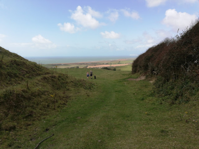
The walk continued; after we left the farm driveway, the path turned steeply right and then even more steeply uphill, coming out on a broad green pathway high above the surrounding farmland. We found an unusual memorial that looked rather like a prone barrel, and which was covered in inscriptions of dates and names. Curious. Once home I did a little searching and am reasonably sure it was a commemoration of shipwrecks off the west coast of the Island. The path soon descended again, and led across the lawn of Pyle Manor then into Windmill Copse, another pleasant patch of woodland. This led past a deer park, where we watched a herd of deer watching us. They were well camouflaged against the hill.

Further on, the path led through a swampy section of woodland, with a rickety boardwalk to walk on. This was fine until the very end where the boardwalk suddenly ran out, so we hopped across the last few feet on semi-sunken branches and logs.  The path led back uphill (not steep) and across a few fields until we returned to Chale Green, muddy, tired and happy.

Route: http://gb.mapometer.com/walking/route_4284746.html
Distance: 4.5 miles
Footpaths: C1, C37, GL60, C3, C5, C4, C21, C22, C23, C33

Mushroom Chairs

Hoy Monument

View to the West Coast

Baa Lamb

Shipwreck Memorial

Primroses

Swamp path