I started the new year off gently by going for a stroll from Quarr Abbey to Binstead and back with a friend. It was a glorious winter afternoon, cold but dry and bright, and we caught up on all the news as we walked. Lovely. We stopped off at Holy Cross church in Binstead on the way back; this is an old church that I have walked past many times but never been in. It has a beautiful wooden 'boat' ceiling, which has Norman style wooden arches overlaying it. The stone pulpit is in just the right spot to survey the congregation and keep an eye on wayward choristers! The church was, unsurprisingly, very tranquil. Worth a visit.
Afterwards we stopped for a hot drink and cake at the Abbey cafe before wandering up to admire the pigs and then toddling off home.
Showing posts with label church. Show all posts
Saturday, 5 January 2019
New Year
Labels:
Abbey,
Binstead,
Challenge 2019,
church,
Hike,
Quarr Abbey
Thursday, 25 October 2018
Godshill and Wroxall
I met up with a chum today and we headed to Godshill, parking in the big car park there. We had decided to follow a route found on 'Visit Isle of Wight', but swiftly went wrong. We made it as far as All Saints Church, on the hill (hence the name of the village I guess), then got a little confused. We walked along the lane, but couldn't see a footpath leading off it, so turned round and went the other way ending up back in the village. It was a pleasant detour, with lots of thatched cottages and few tourists. If we had carried on along the original path we would have got to our footpath. Ah well!
We decided to head through the village to The Griffin Inn as I knew there was a path there that led to Appuldurcombe House, where we wanted to go. This led behind the pub, across a meadow and into woodland, full of fallen leaves and sweet chestnuts. Lovely! We took the path to the right which came out by a deer park and led gradually uphill, coming out at a crossroads of paths. The one straight ahead led up the infamous Gat Cliff and the one on the right skirted round the base of it. I didn't want to go up the cliff as I was feeling particularly unfit today (what a wimp!), so we took the right hand path which eventually led to Freemantle Gate. We went through here and paused for a while to admire it, then continued on to Appuldurcombe House, where we paused to discuss its scandalous history and whether or not it was haunted, as is commonly believed. Onwards from here to the junction with Rew Lane and a brief jaunt into Wroxall.
Wroxall is not a village I know well, but it seemed pleasant and had an unusual church. After a while we found Appuldurcombe Lane and headed back across the fields to Freemantle Gate, pausing to admire a raptor in flight (still undecided on which one it was) and getting excited about a passing spitfire. From the gate we strolled down the lane to Godshill, passing a paddock of Shetland ponies on the way. We ended up in The Griffin for a bite to eat (nice baguettes), then headed to the Willow Tree Tea Garden for a coffee before heading home. Lovely day!
Intended route: https://www.visitisleofwight.co.uk/dbimgs/Walk_Appuldurcombe.pdf
Actual route: https://gb.mapometer.com/walking/route_4826342.html
Distance: 6 miles.
We decided to head through the village to The Griffin Inn as I knew there was a path there that led to Appuldurcombe House, where we wanted to go. This led behind the pub, across a meadow and into woodland, full of fallen leaves and sweet chestnuts. Lovely! We took the path to the right which came out by a deer park and led gradually uphill, coming out at a crossroads of paths. The one straight ahead led up the infamous Gat Cliff and the one on the right skirted round the base of it. I didn't want to go up the cliff as I was feeling particularly unfit today (what a wimp!), so we took the right hand path which eventually led to Freemantle Gate. We went through here and paused for a while to admire it, then continued on to Appuldurcombe House, where we paused to discuss its scandalous history and whether or not it was haunted, as is commonly believed. Onwards from here to the junction with Rew Lane and a brief jaunt into Wroxall.
Wroxall is not a village I know well, but it seemed pleasant and had an unusual church. After a while we found Appuldurcombe Lane and headed back across the fields to Freemantle Gate, pausing to admire a raptor in flight (still undecided on which one it was) and getting excited about a passing spitfire. From the gate we strolled down the lane to Godshill, passing a paddock of Shetland ponies on the way. We ended up in The Griffin for a bite to eat (nice baguettes), then headed to the Willow Tree Tea Garden for a coffee before heading home. Lovely day!
Intended route: https://www.visitisleofwight.co.uk/dbimgs/Walk_Appuldurcombe.pdf
Actual route: https://gb.mapometer.com/walking/route_4826342.html
Distance: 6 miles.
![]() |
| All Saints Church, Godshill |
![]() |
| St John's Church, Wroxall |
Labels:
Appuldurcombe,
challenge 2018,
church,
Godshill,
Hike,
Isle of Wight,
Wroxall
Friday, 27 July 2018
Brighstone
Well, we have had weeks of unending sunshine so today my friend and I decided to go for a walk. It thundered and rained. Of course. However, the thunder was exciting and the rain refreshing so all was good.
We started off in Lynch Lane and headed for the footpath to Moortown (I think that's right; on the right as you head downhill past Coombe Lane), and followed it towards and round Gaggerhill Farm, where we observed some noisy dogs and beautiful horses. The rain started just as we turned into the lane next to the house and we dodged right to a footpath that took us uphill under the trees towards Grammar's Common. This turned out to be a private ("This is not common land") woodland and red squirrel sanctuary, but the footpath went through and we enjoyed the peace and stillness within. At one point we heard a woodpecker and managed to track the noise to three possible trees but could not see the bird itself. Fun looking for it though!
The path led on, out of the woods and down to Strawberry Lane. Here we turned right and picked up a footpath that led to the Long Stone, alongside Castle Hill. We paused in the rain to admire the Long Stone, then detoured to the left and up to the top of Castle Hill to admire the view. One of my favourites, showing the coast from Blackgang Chine to Tennyson Down, even on a cloudy, hazy day like today. We then doubled back and followed the path down through the woods to come out by Mottistone Manor. The manor was not open to the public today, so we crossed the road and prowled around the churchyard, which is a thriving haven for wildlife, and had a look inside the church itself. This is a rather lovely example of a small, country church, and had an interesting display about 'Warrior', the horse that inspired the novel "Warhorse", as he belonged to local landowners.
We had run out of footpath so we followed the road back to Brighstone in search of a cup of tea, only to find that the once famous cream tea shops had disappeared, so we had a cuppa in the Three Bishops pub instead, and bought an ice cream from the village shop. And a Belgian bun. Oops. We did have a slight detour on the way, having seen a signpost that said village centre half a mile; we followed it over a stream (played Pooh sticks on the bridge), and came out on a housing estate with no indication of where to go, so we retraced our footsteps to the main road. After tea, we decided to head back to Lynch Lane, and found another footpath that led over the downs and through a sheep field to Coombe Lane, which we followed passing several stone cottages until we were back in Lynch Lane. Lovely walk!
Distance: 6 miles
![]() |
| Pot Bellied Pig |
![]() |
| Unusual clouds before thunder storm |
![]() |
| Long Stone |
![]() |
| Ordnance Survey Bench Mark on Mottistone Church wall |
![]() |
| Brighstone stream |
Labels:
Benchmark,
Blackgang Chine,
Brighstone,
castle,
challenge 2018,
church,
farm,
Grammar's Common,
Hike,
Isle of Wight,
Longstone,
manor,
Mottistone,
Pub,
Strawberry Lane,
tea,
Tennyson Down
Friday, 16 February 2018
Winchester
Today I accompanied my Mum to Winchester for the first of her expeditions for her new hobby. She has decided to visit all the English cathedrals (C of E predominantly). The day was gorgeous - beautiful winter sunshine - and we had a lovely train journey there. We meandered into the city centre and poked around a few shops and the concourse near the Great Hall before heading to the cathedral refectory for lunch. Oh my! I had slow cooked belly pork on mashed potato with cabbage and wholegrain mustard gravy and every single morsel was scrumptious. Mum had chicken pie, mashed potato and vegetables which was also scrumptious.
We then headed into the cathedral and were greeted by a friendly volunteer who let us know that there would be a guided tour shortly, so we hung around until it started. The guide showed us round and gave us the architectural history of the building - most of what we see is not the original Norman building, but the 14th century redesign. At the East end of the building is a portion that is in the original state, rather solid and with rounded arches piled on top of each other rather than tall pointed arches. He pointed out the font, made of a relatively soft black limestone with fascinating scenes from the life of Saint Nicholas. Some of them were a bit gruesome but still interesting. We saw Jane Austin's tombstone (of course) which doesn't mention her writing, and then onto the 'Holey Hole' where medieval pilgrims crawled to get close to the relics of Saint Swithun. There was lots of medieval tiling on the floor here as well as some more modern replicas. We also saw a chapel that had pre-reformation paintings on the walls that had been plastered over before the reign of Henry VIII. Rather lovely. Lastly we went to the flooded crypt and admired the Anthony Gormley statue that is down there,. The tour ended there, as part of the cathedral was closed for cleaning. Afterwards we popped into a small exhibition showing the Winchester Bible - a handwritten, illuminated edition in four volumes which was absolutely beautiful.
The interior of the cathedral is lovely, with elaborate chantries for long dead bishops, a magnificent stone altar screen, intricately carved woodwork, swooping arches and vaulted ceilings, decorative floor tiles in the older part, a wide variety of memorial plaques to local notables, gentry and military figures, and lovely side chapels some with stunning stained glass windows. The huge window at the west end of the cathedral is worth a look; it is a patchwork of stained glass. This is because Winchester was pro-royalist in the civil war and the rest of the county wasn't, so the original window got smashed to bits. Once Charles II was on the throne as many bits of stained glass as could be found were collected up and put back into the window any old how with clear glass to fill the gaps. Really rather a good effect!
We left late afternoon and visited the gift shop and then had tea and cake in the refectory, explored the outside of the cathedral and found a second hand bookshop that raises money for the choristers, then headed back inside for choral evensong. This was very calm and lovely, with a visiting choir, the Cheriton Singers. Talented bunch. We then headed back to the railway station and home. Pleasant day.
![]() |
| Statue in crypt |
![]() |
| detail of carving |
![]() |
| Cathedral entrance |
![]() |
| Cathedral from the Close |
Labels:
Cathedral,
challenge 2018,
church,
North Island,
restaurant,
Winchester
Sunday, 4 February 2018
Quarr to Ryde
A quick walk on a bright but chilly February afternoon to get back in gear for walking. The teenager has signed up for the Duke of Edinburgh's Award and has chosen walking for her activity. As we have been spectacularly inactive lately we decided to start with something simple and headed for Quarr Abbey after stopping for lunch at Bluebell's Cafe (always delicious!).
We began the walk by stopping to admire the pigs, as is traditional, then strolled through the woods to the ruins of the medieval abbey and on to the main path towards Ryde. This took us to Binstead Church, and then the path cut through the golf course and up to the main road. We turned back at this point and returned to Quarr.
This was, as ever, a lovely walk. There were signs of spring everywhere with catkins on the trees, snowdrops in the verges, and blackbirds and robins twittering in the trees. Lots of families were out enjoying the sunshine, and everybody we met appeared to be in a good mood.
We began the walk by stopping to admire the pigs, as is traditional, then strolled through the woods to the ruins of the medieval abbey and on to the main path towards Ryde. This took us to Binstead Church, and then the path cut through the golf course and up to the main road. We turned back at this point and returned to Quarr.
This was, as ever, a lovely walk. There were signs of spring everywhere with catkins on the trees, snowdrops in the verges, and blackbirds and robins twittering in the trees. Lots of families were out enjoying the sunshine, and everybody we met appeared to be in a good mood.
![]() |
| Quarr Abbey |
![]() |
| Holy Cross church, Binstead |
Labels:
Binstead,
challenge 2018,
church,
D of E,
Hike,
Isle of Wight,
Quarr Abbey,
Ryde
Sunday, 31 December 2017
November and December 2017
It has been a quiet couple of months as I have been struck down with viral vertigo and unable to do much. Christmas was spent quietly with family, starting off with candlelit Nine Lessons and Carols at St Mary's Church, then a week later the Nativity at Holy Trinity Church, followed by Midnight Mass at St Mary's. I hadn't been to Midnight Mass for years and it was really rather lovely.
Yesterday I dragged a friend out and we went for a soggy stroll around Newtown (I always forget how wet it is in the winter), followed by a delicious cup of hot chocolate at the Cow Co. at Tapnell Farm. Lovely!
Today I went to the Quay Arts Centre in Newport for their Sunday Recital; this was Paul Armfield and friends and jolly good they were too! Paul was joined by, among others, Tom Thorne on piano, John Thorne on double bass, Wilf Armfield on drums, JC Grimshaw on guitar and mandolin, Angelina Grimshaw on guitar and vocals, other Grimshaw's on violin and guitar, and some extremely talented chaps on violins and mandolin. The start was slightly shambolic, but as more people joined in everything came together and a lovely time was had by all. A great way to spend a damp Sunday morning ( and the tea was good too!).
Labels:
Café,
Challenge 2017,
church,
gig,
Isle of Wight,
Quay Arts,
Tapnell
Tuesday, 15 August 2017
Newtown
A lovely walk today, and not too taxing in the summer heat (remarkable considering the miserable weather of the last week). I met a friend in the main car park at Newtown and we ambled along the road past the old Town Hall, and shortly after turned onto a footpath leading along the creek. This crossed a couple of fields, then led through a wooded path and back onto the road.opposite the church. A little way beyond this was a path leading past an old house and down to the Mercia Seabrook bird hide, which we popped into briefly; it had a few people searching for birds on the wetlands and woods beyond, and we decided not to stay. Instead we walked across the field next to the hide and across the wooden footbridge to the remains of Newtown Quay, then out along a strip of land that jutted into the harbour. We stopped here for a bit, admiring the view and enjoying the peaceful atmosphere; there were few people around and we were surrounded by sea and countryside. Absolutely lovely.
We retraced our steps to the quayside then walked round the salt pans and across the field back to the road, and then onto another footpath behind the church, back to the road and along to the ancient house known as 'Noah's Ark'. This is, I think, the oldest building in Newtown and was at one time a pub, and has been many other things too. On the front is a plaque bearing the name 'Francheville', which was the medieval name for the, then, town and translates to Free Town. The plaque displays a picture of a boat and a lion, and is where the current name of the house comes from.
We went back down the road a little and picked up a footpath that led through fields and across the road to Walter's Copse. This is a lovely little copse, full of wild flowers and peace; we didn't walk all the way round it as intended, as we missed a side path. When we came out of the copse, we followed Town Lane back to the car park, and then went to the Town Hall and looked round inside (£4 a head). Upstairs were various pieces of antique furniture, clocks, Hogarth prints, a replica of the town seal and a magnificent fireplace. Downstairs, via a twisting, cast iron staircase, was a cool room with a history of the 'Ferguson Gang', a formidable group of ladies early last century, who bought various properties around the country, including Newtown Town Hall, and presented them to the National Trust. I suspect that I would have liked them immensely! There was also an ancient ring-dial telephone where you could dial up various oral histories of the area, and copies of ancient documents about the town.
Once finished, we followed the lane down to the 'main' road and headed for Shalfleet where we had tasty sandwiches at the New Inn before heading back to the car and then home. It is amazing that this unassuming village with its wonderful wildlife and countryside was once the most important town on the Isle of Wight.
![]() |
| Old Town Hall, Newtown |
Route: (roughly) https://gb.mapometer.com/walking/route_4596372.html
Route we meant to take: https://www.nationaltrust.org.uk/newtown-national-nature-reserve/trails/enjoy-the-estuary-newtown-walk
Distance: 5.5 miles
Labels:
Challenge 2017,
church,
Hike,
Isle of Wight,
National Trust,
Newtown,
Pub,
Shalfleet,
Town Hall
Friday, 28 July 2017
Blackgang to Whale Chine
Quick walk today as the weather was looking dodgy. We parked at Blackgang Chine viewpoint car park (further up the hill from the theme park, and free), and followed the coastal path onwards Chale. The path appeared fairly well used, but had nettles growing abundantly alongside it, so longer trousers than mine are to be recommended! And boots rather than hiking sandals. However, not too many stings and they wore off quickly. The path opened onto a field, the overflow car park for Blackgang Chine, led across it and back to the road. We followed the road downhill, over the traffic island, and rejoined the footpath on the left that led to the village. The footpath followed the road again, past the ancient St Andrew's church at Chale, and then turned left at the showground and headed towards the cliffs.
We continued along the cliff edge, admiring the dramatic scenery while also wondering whether we would inadvertently end up on the beach in a cliff fall as there appeared to be rather a lot of large cracks in the ground! The path ended abruptly at a large mound and turned inland over a make shift bridge, then back along the coast past a building that might have been a gun emplacement at one time. Hard to tell! The weather was in turns very blustery and then dead calm, which was odd as there weren't major changes in the landscape or the wind. It felt as though we would take off occasionally, and we laid flat on the ground to have a good look at a small chine (we saw two, Ladder Chine and Walpen Chine), without being blown over the edge! Once we reached, and had a good look at, Whale Chine, we turned back and followed the road until we got back to Chale. This was fairly uneventful, and we saw three beautiful alpacas along the way near the small, thatched Walpen Manor house.
Once we reached the car, the weather changed to wet and windy, so we decided a cup of tea was in order and headed to Isle of Wight Pearl, had a look at the jewellery, and had a cuppa and a bowl of homemade tomato soup to warm our cockles! Lush!
Route: https://gb.mapometer.com/walking/route_4585224.html
Distance: 4.3 miles
Distance: 4.3 miles
![]() |
| Ladder Chine or Walpen Chine |
![]() |
| Landslip with scout signs |
![]() |
| Alpacas near Chale |
![]() |
| St Andrew's Church, Chale |
Labels:
alpacas,
Blackgang Chine,
Café,
Chale,
Challenge 2017,
Chine,
church,
Coastal path,
Isle of Wight,
Ladder,
manor,
pearl,
tea,
Walpen,
Whale
Sunday, 13 November 2016
Shorwell and Chillerton Down
Off for another stomp on a glorious autumn afternoon. We drove along Middle Road to Shorwell and parked near St Peter's Church, changed into our boots and headed to the footpath behind the church. This led past some pleasant houses, and a glorious patch of fungus, and uphill towards the downs. The path led gradually upwards towards Chillerton TV mast, with a steep climb at the end past a disused chalk pit.
Once we reached the fenced off TV mast we hit a problem; we followed the perimeter to the left and came to a barbed wire fence where the path appeared to plunge down the side of the chalk pit. Very steep, so no thank you! There didn't appear to be a way through, even though the map showed a footpath, so we turned round and followed the fence to the other side of the TV mast. This at least gave us some beautiful views of the surrounding downs and coast, and the village of Chillerton, bathed by the light of the late afternoon sun. Gorgeous.
However, when we got to the other end of the fence we could see the path over another never-ending barbed wire fence. Hmm. No way through seemingly, so, I'm not sorry to say, we hopped over a 'No entry' gate and high-tailed it for 100 yards until we found a gate onto the footpath. We were a right pair of nervous Nellies, quite concerned somebody would come out and shout at us, but they didn't, thankfully! Once home I looked at the route online and realised that if we hadn't cut up past the chalk pit the path would have led to where we wanted to be. Nice to know our map reading skills aren't improving...
When back on the path it was a straightforward walk back along a couple of tracks and through a field to Shorwell village and the car. Another nice drive along Middle Road, with a glimpse of this months super moon towards the end. Perfect!
Distance: 4 miles
![]() |
| Fungus |
![]() |
| Lovely landscape |
![]() |
| More lovely landscape |
![]() |
| St Peter's Church |
Labels:
Challenge 2016,
Chillerton,
church,
Hike,
Isle of Wight,
Shorwell
Sunday, 11 September 2016
Arreton
After a lazy summer my hiking buddy and I decided to get back out into the countryside again today. We drove up to Robin Hill to drop her family at Bestival (after we'd driven back to collect the tickets), then pootled down the road to Arreton Barns. We had no map, obviously, but thought we remembered the route of a nice walk. We were mostly right.
We walked through the barns site, past the duckpond and St George's church, and came out on the main road. Here we crossed over the road and entered a cabbage field. We walked all the way up the track to find a wire fence with no way through, so retraced our steps to find a path through the cabbages on our right. This also led to a fence, but we were able to hop over it to an obvious path on the other side. This led in due course over a couple of stiles and brought us onto the main Newport to Sandown cycle path. We headed towards Sandown, and shortly after found a path on our left leading to Haseley Manor; this mostly consisted of boardwalks as the path was rather muddy, and came out right next to the Manor House. Last time we were here the path was closed so it was nice to see the work that had been done.
From Haseley, we walked away from the road, past the outbuildings, and towards the downs. The path led us to a lake, rather low on water after the summer sunshine, and we walked round it, scaring the waterfowl, until we met back up with the main path. From here we continued up the hill on a farm track thinking that if we got to the top we would be able to get a glimpse of Bestival. However. It was a hot day, we were tired and unfit, so when we got to a gateway by the woods we sat down and talked ourselves out of it. Turns out we wouldn't have seen anything anyway! Back down the hill to the lake, turned right and followed the path back to Arreton Barns. Here we made a few purchases at Farmer Jacks farm shop and then had a drink on the terrace at the Dairyman's Daughter, and listened to a trio of musicians who were jolly good. Lovely afternoon!
![]() |
| Hasely Manor |
![]() |
| Teasels |
![]() |
| View from the gate |
![]() |
| St George |
![]() |
| Arreton Church |
Labels:
Arreton,
Bestival,
Challenge 2016,
church,
Hike,
Isle of Wight,
manor,
Pub
Sunday, 24 April 2016
Whitwell and Stenbury
Another Sunday afternoon stroll on our beautiful Island. This time we headed south to Whitwell and parked near the church, and followed the route suggested by Isle of Wight Ramblers route 'Whitwell, Stenbury' in their 'Twelve more favourite walks' booklet.
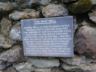
The route led us up the main road past the church and rectory, then turned left down a broad footpath between houses. On the side of the footpath was an old water hydrant, installed in the village in the 1800s, and the 'White Well' which the village is apparently named after. This used to be a place of pilgrimage for the healing water's of the well, dedicated to 'Our Lady of Whitwell and St Rhadegund'.
The path led on down to a stream and then across a field to a metal gate. Apparently the old railway line led through here, but there was nothing obvious to suggest this (we looked hard!). The path continued upwards towards Nettlecombe, a hamlet that is all that remains of a medieval village, and past three large ponds on the way. Nettlecombe looked lovely - a small community nestled in a valley with countryside to die for. It was the best venue for sledging that I have ever seen! The pathway continued uphill, via NT3 and NT119, onto Stenbury Down. The views across the Island were magnificent; we could see all the way up to Tennyson Down and down the coast to Blackgang then round the southern end of the Island. Turning the other way we could see the Solent. In between all of this was beautiful, rolling countryside with fields as far as the eye could see, and spring flowers in every verge and hedgerow. Glorious.
We followed the path to Week Farm, crossed the farmyard and continued on up the hill towards metal towers that overlooked Wroxall, and where the path joined with the route to Gat Cliff and Appuldurcombe. At this point we turned left and plunged steeply downhill towards Newbarn Farm, said hello to the farmer as we crossed the farmyard, and followed a path past sheep paddocks. Here we saw a newly born lamb, still wet and bloody, lying near its mother and the placenta. Strangely cute! There were lots of lambs here, of varying ages, gambolling happily around the fields. We saw a couple feeding and their little tails were waggling with joy! The country here seemed ageless, and we could well imagine that not much had changed for several centuries and almost expected Mr Darcy to come galloping over the hill. He didn't, sadly. We passed moss-covered, crumbling, dry stone walls, and tripped along an uneven pathway towards Stenbury Manor and passed between this building and the farm outbuildings. The manor appeared shut up, with shutters at every window, but that could just have been to keep out the prying eyes of passing walkers.
After the manor the path returned to Nettlecombe, over a series of stiles and past more happy lambs, and eventually rejoined the well path and back to Whitwell. We decided we needed a cup of tea so drove to The Buddle Inn in nearby Niton to get one. We also ordered cheesecake which turned out to be rather more expensive than we anticipated, but was suitably yummy.
This was a delightful walk, not too muddy, and steep in places, with lovely wildlife. We saw flowering gorse, blackthorn blossom, cowslips, primroses, stitchwort, bugle, bluebells, rabbits, horses, cock pheasants in full spring glory, hen pheasants, alpacas, cattle, sheep and lambs.
Distance: 4.5miles
Pathways: NT3, NT119, NT9, V62
![]() |
| Bluebells |
![]() |
| Rolling countryside |
![]() |
| Wind-blasted trees |
![]() |
| Stenbury Manor |
Labels:
Challenge 2016,
church,
Hike,
manor,
Nettlecombe,
Niton,
Pub,
Whitwell
Saturday, 9 April 2016
Medina Estuary
Today was the annual sponsored walk for St. Mary's Church, so I thought I'd join in. Some parishioners met up at the Church, and the rest of us met at the start of the Cowes-Newport cycle track on Arctic Road. Once we had all gathered here, (there were 14 of us), we set off for Newport. The weather was pleasant and warm, and we got going at a good pace chattering away and admiring the views of the River Medina, as well as dodging cyclists and runners. A popular path! After about an hour we reached Dodnor picnic area and were met by two chaps who had laid a tablecloth over a picnic table and provided tea, coffee and biscuits for us. Very nice! Once refreshed we headed on to Newport, popped into the Quay Arts Centre to use the facilities and said goodbye to four of the walkers who were now going home.
The rest of us picked up the path on the opposite side of the river and strolled on past the site of the Isle of Wight Festival, and onto a newly refurbished path along the river to Island Harbour. At Island Harbour we used a lock gate to cross over the harbour entrance and onto the next part of the path. Shortly afterwards we saw that the pathway was closed, but thought we'd chance it and carried on anyway, especially after walkers coming in the opposite direction said they had got through. However, we soon discovered that the main route was underwater and wandered up the field edge looking for an alternative. Unfortunately, one of our party slipped over in the mud and hurt his ankle, and the weather turned cold, wet and squally, so we decided to head back to the harbour before there were any more accidents. Luckily there was a café there, The Breeze, so we stopped for a coffee, called the injured chap's wife to collect him and decided what to do next. Half the party decided to head back to town and catch the bus home, and the remaining five of us decided to continue on a slightly alternative route.
We headed up the lane to the main Newport to Ryde road, turned left and picked up the old East Cowes Road, then walked along until we got to Beatrice Avenue. We headed down here towards St Mildred's Church, designed by Prince Albert, and then down through a housing estate and into East Cowes and thence to the chain ferry and home. We managed to run for the chain ferry as we could see it was about to leave and really didn't want to sit around and wait for the next one, and the lovely operators waited for us.
This was a lovely walk with lovely people and I shall try and tag along again next year!
Distance: 11.7 miles
![]() |
| Sculptures at Seaclose park |
![]() |
| PS Ryde Queen at Island Harbour |
![]() |
| Bench at Whippingham |
![]() |
| St Mildred's Church, Whippingham |
Labels:
Challenge 2016,
church,
Cowes,
cycle path,
East Cowes,
harbour,
Hike,
Newport,
Quay Arts
Friday, 8 April 2016
Mottistone to the Sea
I dragged the teenager into daylight and headed for the West Wight today. We parked at the National Trust car park at Mottistone Manor, then followed their suggested route towards the coast. This led through the churchyard down a short lane, over a stile and onto a footpath. This was slightly squishy in places, but had a stream to the right, and plenty of herbage; the nettles were growing, and cow parsley was coming into bud, and all the hedgerow plants were greening up. We followed a pair of mallards to a wild meadow, where they took to a small pond, and we continued onwards.
The path turned right at a junction, bordered by a laid hedge to the left, and we headed onwards to walk along the edge of another stream and a small woodland. This latter was very pretty in the dappled sunlight, with the deciduous trees putting out leaves, and masses of cow parsley on the path. We could hear the songbirds warbling in the trees and hedgerows and noticed a few bees and bumblebees buzzing among the early wildflowers. The path crossed a small bridge and another stile into a rather soggy meadow, coming out after a little while onto the military road.
We turned right, passed two cottages, then crossed over the road to follow a permissive path through fields to the cliff edge at Sudmoor Point, and picking up the coastal path. There was a glorious view here all along the coast from Blackgang to Tennyson Down, and looking down over the landslip we could see that the tide was far out and that the rocky reef was exposed. Unfortunately there was no access to the beach as far as I could see, so we didn't get closer. The teenager was tired so that was probably a good thing! We followed the coastal path for a while until we met a footpath going inland, and followed this back to the military road, and then crossed over and picked up the final path back to Mottistone. This was a lovely farm track between high hedges, secluded from the breeze and warm in the spring sunshine, and led us back to the church and then the car park.
As the teenager had made it all the way round, I rewarded her (and me, obviously) with an ice cream from the van at Compton Bay before driving home along lots of country lanes, avoiding many suicidal pigeons and a pheasant.
Distance: 2.8 miles
Footpaths: BS74, Coastal Path, BS75, BS100
![]() |
| Mottistone Church |
![]() |
| Woodland Stream |
![]() |
| View from the coastal path towards Freshwater |
Labels:
Challenge 2016,
church,
Coastal path,
Hike,
manor,
Mottistone,
National Trust
Sunday, 17 January 2016
Niton, Whitwell and Bierley
Time to start training for this year's 'Walk the Wight', so we headed off to Niton full of confidence in our route-finding abilities. Oops. Once we got to Niton (easy) and parked (also easy), we headed confidently off only to realise after five minutes that we had gone in the wrong direction. We retraced our steps, consulted the map as well as the walking guide, and found a footpath that was heading in the right direction. We also found a friendly local who reassured us that we were indeed heading the right way. Phew!
We followed the path past the primary school, along Allotment Road, and into a muddy field, and squelched up the track towards Whitwell. We passed the cottage mentioned in the book and whooped with happiness! The rest of the walk went to plan, and involved several extremely squelchy footpaths and bridleways, and a walk through a quiet woodland on the downs with many elderly trees. One footpath was bordered with bracken and was soft underfoot with dead bracken leaves. Lovely. The views over the countryside of this part of the Island were lovely, and would have been spectacular on a sunny day, rather than a damp and drizzly Sunday afternoon in January.
Points of interest included the rather ancient and lovely churches of Niton and Whitwell, and the unexpected delight of Stockbridge Manor and its Alpacas.
Distance: 4 miles
Route: http://gb.mapometer.com/walking/route_4229021.html
![]() |
| Whitwell Church |
![]() |
| Whitwell Church |
![]() |
| View from the Downs |
Subscribe to:
Posts (Atom)