Showing posts with label Niton. Show all posts

Wednesday, 28 August 2019

Niton and Bierley

Another walk with friends today, again starting in Niton. We headed up Pan Lane to Niton Shute and up to the top of the downs, filling our faces with blackberries enroute. From here we headed along the ridge towards the Hoy Monument but took a path on the right hand side a few hundred yards before we reached it. This led downhill through a small wood with fallen sycamores and lots of nettles; wild and lovely.

The path led past a cottage and across the top of a field, through a gate and into another field. After a scramble past a fallen willow and up a bank we discovered a large herd of cows and calves. We were a little nervous as the cattle were stood right on the footpath and we had two dogs with us (on leads). However, we got past without incident, passed through a gate and into a shady lane with views to a manor house, and followed a path by a stream through the woods. This eventually turned uphill and to the right, leading past an ancient carp pond on the left and then down to meet another stream where we found a small, hidden waterfall. Gorgeous! We got back on the path, found the road and followed it through Bierley and Kingates to Niton and lunch at the White Horse. Excellent excursion!


Monday, 19 August 2019

Niton and Chale

Gorgeous walk with friends today after a week of miserable weather. We started in Niton and headed up Pan Lane to the downs, then followed the path to the Hoy Monument. Along the way we were picking and eating plump blackberries and admiring the many wildflowers in the hedgerows and in the fields.  We turned left near the monument, walked down the path to a junction and turned left again heading eventually over fields, past a dairy farm, and down to the road. We turned left again and before very long were at the Wight Mouse Inn at Chale. We stopped for lunch, obviously! This was scrumptious, and I recommend the stilton burger.

After lunch we carried on along the road to the junction with the military road, turned left and picked up the coastal path and headed uphill towards Blackgang Chine. The next path went over a field, the oversold car park, and headed upwards to Blackgang View Point car park. Fantastic views up the west coast from here. At the far end of the car park we picked up the next path and headed for a time along the cliff top in a stiff breeze before turning left after a stone wall and picking up a path back to Niton. This led past a wheat field and eventually back to the village. There were more glorious views here, across to the downs in the late afternoon sunshine. We live on a beautiful Island.

Route: www.plotaroute.com/route/907930
Distance: c. 5.5miles


Thursday, 30 May 2019

Niton and St Lawrence

Today's adventure was around the south of the Island. We parked at the top end of St Catherine's Road then walked down and joined Castle Haven Lane. We followed this past some lovely gardens and a great view of St Catherine's Lighthouse, down to the beach, where we found several lobster pots, a cafe and some huts. The tide was very high so after walking along the rock sea defences we turned back and walked up to Undercliff Drive.

Undercliff Drive has been closed to through traffic for several years due to a large landslip. We ambled along it for some time, passing woodland, interesting houses, snails, crossing a bridge and a strange stone inscribed with initials and a date and surrounded by a cage. No idea what it was for! We also found the remains of a stone cottage in a small nature reserve which had a small cloud of bumblebees buzzing round it. There were also enormous fungi!

We followed Undercliff Drive to Ventnor Botanic Gardens and had a very pleasant lunch in the cafe there. Afterwards we had a mooch around the gardens (Gardeners World 2 for 1 card came in handy here!) admiring all the interesting plants and then joined the coastal path and started our way back.

The coastal path led past Orchard Bay. We could see a rock at the far end with three cormorants on it, so we went down the steps and crossed the beach to have a closer look. This was a new beach to me and I really liked it! The beach was covered in fine shingle (not ideal when wearing sandals) but had big rocks at the bottom and sides which were great for scrambling on. We got quite close to the cormorants and then had an explore of the rocks and rock pools; there were lots of clusters of winkles (I think. Sea snails anyway.) in depressions in the rocks, and a lot of limpets. As we made our way back over the rocks near the steps we saw a lizard - really exciting! Neither of us had seen one before. We then saw a wren, which was nice but not as exciting.

Back up the steps then to follow the coastal path to St Lawrence and up a side path leading to St Lawrence Old Church. This was delightful. The church is small, seating perhaps 60 people, and dates from the twelfth century. The first rector was called Roger! There is a beautiful pre-raphaelite stained glass window there too.

We walked back into the village and rejoined Undercliff Drive and made our way back to the car. A really lovely, interesting walk.

Distance, including the botanic gardens, approx. 16km.

Route: https://www.plotaroute.com/route/843531?units=km


Friday, 3 June 2016

St Catherine's Lighthouse

A short but beautiful walk today. I met up with a friend, her tweenager and her dog and we drove to St Catherine's Road in Niton, and parked beyond the Buddle Inn. The private road beyond this led steeply downhill, between hedgerows in full flower, towards St Catherine's Lighthouse on the most southerly tip of the Island. At the end of the lane, just before the lighthouse we climbed a stile to our right and crossed into a meadow. The footpath led past an enormous rock (perfect for scrambling up) covered in sea thrift (Armeria), and then towards and then along the cliff edge. The ground here is notoriously unstable and we could see the results of past landslips in the surrounding landscape.

We followed the path through a buttercup-strewn meadow, over another stile, and down to Watershoot Bay, a very rocky beach. Lovely though. Behind the beach was some woodland so we scrambled up to it and had an explore, finding the remains of a couple of camps that locals had made. The dog was having a lovely time running around the undergrowth, and we had fun exploring more slowly!

We made our way back to the beach and retraced our steps back to the car, pausing briefly to admire the cattle in the field by the road. I'll definitely go back and explore some more!

Footpath: NT37
Distance: 1.5 miles

St Catherine's Lighthouse


Sunday, 24 April 2016

Whitwell and Stenbury

Another Sunday afternoon stroll on our beautiful Island. This time we headed south to Whitwell and parked near the church, and followed the route suggested by Isle of Wight Ramblers route 'Whitwell, Stenbury' in their 'Twelve more favourite walks' booklet.

The route led us up the main road past the church and rectory, then turned left down a broad footpath between houses. On the side of the footpath was an old water hydrant, installed in the village in the 1800s, and the 'White Well' which the village is apparently named after. This used to be a place of pilgrimage for the healing water's of the well, dedicated to 'Our Lady of Whitwell and St Rhadegund'.


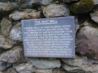
The path led on down to a stream and then across a field to a metal gate. Apparently the old railway line led through here, but there was nothing obvious to suggest this (we looked hard!). The path continued upwards towards Nettlecombe, a hamlet that is all that remains of a medieval village, and past three large ponds on the way. Nettlecombe looked lovely - a small community nestled in a valley with countryside to die for. It was the best venue for sledging that I have ever seen! The pathway continued uphill, via NT3 and NT119, onto Stenbury Down. The views across the Island were magnificent; we could see all the way up to Tennyson Down and down the coast to Blackgang then round the southern end of the Island. Turning the other way we could see the Solent. In between all of this was beautiful, rolling countryside with fields as far as the eye could see, and spring flowers in every verge and hedgerow.  Glorious.

We followed the path to Week Farm, crossed the farmyard and continued on up the hill towards metal towers that overlooked Wroxall, and where the path joined with the route to Gat Cliff and Appuldurcombe.  At this point we turned left and plunged steeply downhill towards Newbarn Farm, said hello to the farmer as we crossed the farmyard, and followed a path past sheep paddocks. Here we saw a newly born lamb, still wet and bloody, lying near its mother and the placenta. Strangely cute! There were lots of lambs here, of varying ages, gambolling happily around the fields. We saw a couple feeding and their little tails were waggling with joy! The country here seemed ageless, and we could well imagine that not much had changed for several centuries and almost expected Mr Darcy to come galloping over the hill. He didn't, sadly. We passed moss-covered, crumbling, dry stone walls, and tripped along an uneven pathway towards Stenbury Manor and passed between this building and the farm outbuildings. The manor appeared shut up, with shutters at every window, but that could just have been to keep out the prying eyes of passing walkers.

After the manor the path returned to Nettlecombe, over a series of stiles and past more happy lambs, and eventually rejoined the well path and back to Whitwell. We decided we needed a cup of tea so drove to The Buddle Inn in nearby Niton to get one. We also ordered cheesecake which turned out to be rather more expensive than we anticipated, but was suitably yummy.

This was a delightful walk, not too muddy, and steep in places, with lovely wildlife. We saw flowering gorse, blackthorn blossom, cowslips, primroses, stitchwort, bugle, bluebells, rabbits, horses, cock pheasants in full spring glory, hen pheasants, alpacas, cattle, sheep and lambs.

Distance: 4.5miles
Pathways: NT3, NT119, NT9, V62

Bluebells

Rolling countryside

Wind-blasted trees

Stenbury Manor


Sunday, 17 January 2016

Niton, Whitwell and Bierley

Time to start training for this year's  'Walk the Wight', so we headed off to Niton full of confidence in our route-finding abilities. Oops. Once we got to Niton (easy) and parked (also easy), we headed confidently off only to realise after five minutes that we had gone in the wrong direction. We retraced our steps, consulted the map as well as the walking guide, and found a footpath that was heading in the right direction. We also found a friendly local who reassured us that we were indeed heading the right way. Phew!

We followed the path past the primary school, along Allotment Road, and into a muddy field, and squelched up the track towards Whitwell. We passed the cottage mentioned in the book and whooped with happiness! The rest of the walk went to plan, and involved several extremely squelchy footpaths and bridleways, and a walk through a quiet woodland on the downs with many elderly trees. One footpath was bordered with bracken and was soft underfoot with dead bracken leaves. Lovely.  The views over the countryside of this part of the Island were lovely, and would have been spectacular on a sunny day, rather than a damp and drizzly Sunday afternoon in January.

Points of interest included the rather ancient and lovely churches of Niton and Whitwell, and the unexpected delight of Stockbridge Manor and its Alpacas.

Distance: 4 miles
Route: http://gb.mapometer.com/walking/route_4229021.html

Whitwell Church

Whitwell Church

View from the Downs