Well, we had a plan. We were going to follow the National Trust route from Luccombe Down, via the Devil's Chimney, down to the beach and then back up the BIG hill. Hmmm. Sounded good. However, we got a bit lost trying to find the car park and had a grand tour of Upper Bonchurch, the local countryside and Shanklin duck pond before we figured out where it was. By this time it was nearly 3pm on a slightly gloomy autumn afternoon and we were not as keen as we had been.
Onwards and downwards though, but ditching the original route. We parked at the end of a chalk track on top of Luccombe Down and admired the magnificent views across Sandown Bay, and also the English Channel. We marched off down the Down, heading down Nansen Hill and emerging on the road opposite Smugglers Haven tea rooms by Devil's Chimney. We continued along the road for a bit, before finding the footpath on the right. Once through the gate we were confronted with a hill full of feral goats. Now, I'm reasonably sure that they posed no threat, but they had ENORMOUS horns - at least half as big as each goat - and, quite frankly, we feared for the safety of our kneecaps if we irritated them. Also, they could run faster than us. It's not that we're a pair of big ol' scaredy cats, honest.
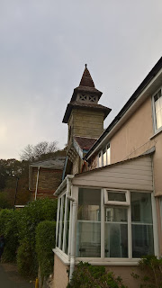
Back to the road in search of another footpath heading upwards, which we eventually found just past a bend in the road. On the way we were able to admire the variety of architecture in the area - the locals seem to have a thing for random turrets on their houses, - and the breathtaking, vertigo inducing, views of the town below. We found our path in the woods, but quickly realised it was treacherous so turned back; the path was narrow and steep with a precipitous drop down to the road below. Not only that, it was covered with a slippery layer of evergreen oak leaves, so turning back was really the sensible option.
We followed the path in the other direction, still through the woods but much more level, past tennis courts and grand Victorian Villas and came out on the road near the Bowling Club. We continued on the road until we got to the industrial estate and took the steep footpath there back up the down. Oh. My. Goodness. It was steep. We stopped regularly for a breather - the wind was strong and took our breath away - and eventually got to the top. Phew! The view of the town below and the surrounding hills was incredible.
The final slog took us past WW2 pill boxes and Ventnor Radar Station, which was bombed heavily in the war. I had heard rumours of an underground town under this hill years ago, and found an information board saying that there was in fact a Cold War era nuclear bunker there. I need to see this! Very exciting, but unlikely to be open to the public sadly.
An excellent, invigorating walk, and we'll do the original route another day. When we're fitter. And have warmer clothing.
Distance: approx. 3.5 - 4 miles.
 |
| View to Sandown Bay |
 |
| Bonchurch |
 |
| Random turret |
 |
| Pill box |
No comments:
Post a Comment
Note: only a member of this blog may post a comment.